

Yavapai County
Tule Creek Homestead/China Dam
China Dam and the Tule Creek Homestead are a set of abandoned structures in the creek bottoms north of Lake Pleasant. The area around Lake Pleasant has long been rich with mining history. Far before the creation of the lake, people flocked to the area in hunt of riches – gold, silver, and more lay in the southern foothills of the Bradshaw Mountains. Both of these historic sites sit along the moderately difficult Tule Creek/China Dam Trail and can be explored in a few hours.
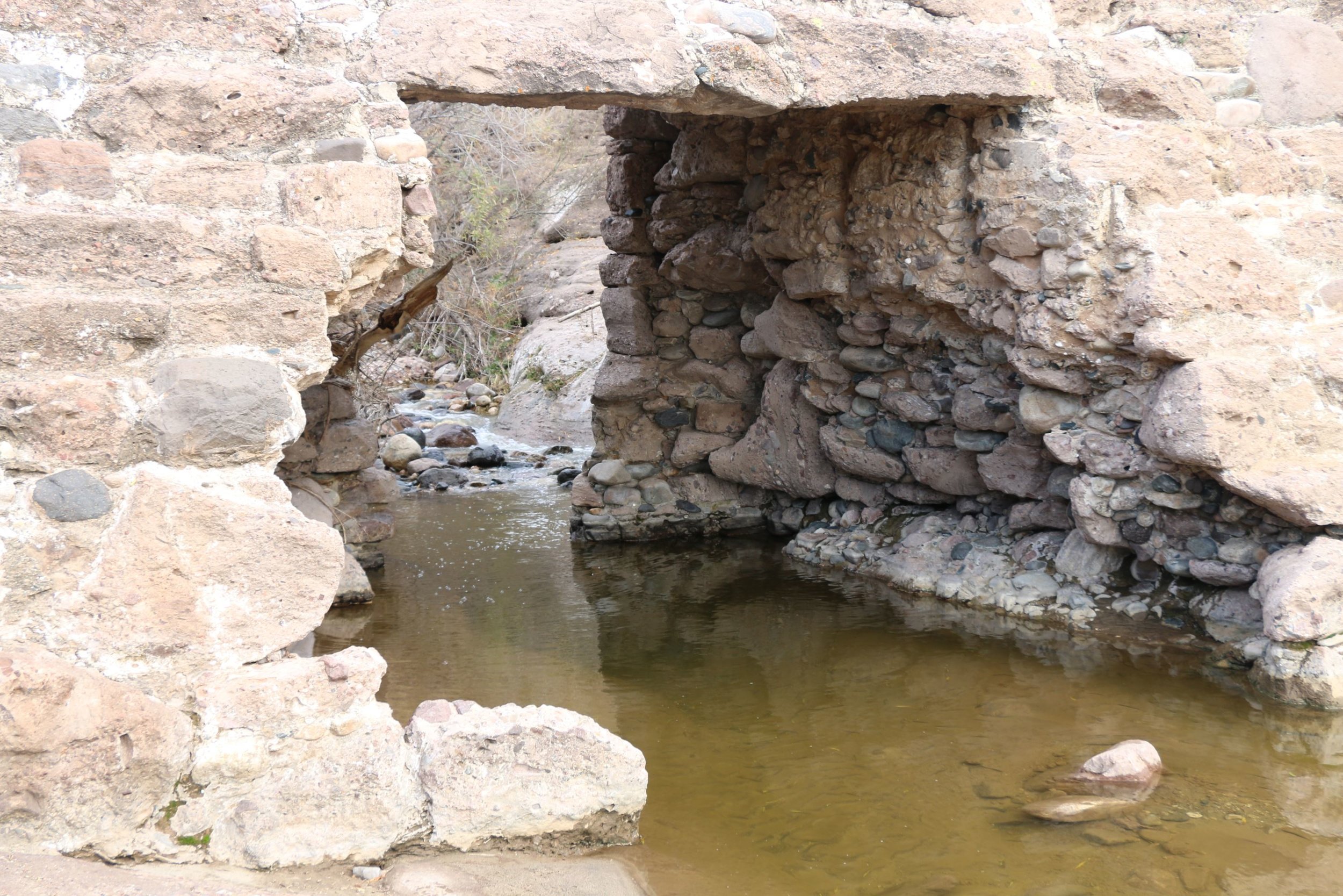
China Dam consists of a series of concrete dams built along Humbug Creek. The creek reportedly got its name from miners who worked the area, only to be disappointed by not finding anything substantial. The dam itself is actually made of two separate dams. Upper China Dam sits closer to the western bank of Humbug Creek and is much lower and less prominent than the main dam. The dam has been backfilled with sediment from the creek and you can actually park on and walk across the top of it.
The main China Dam is much more impressive, and at one point, blocked the main channel of the creek. Not a lot of information is published on the area, but the dam was likely constructed in the late 1890s or early 1900s. The dam was constructed by Chinese workers, hence the name. The purpose behind the dam was to stop the water flow and use said water in hydraulic mining efforts to the north. Further upstream along Humbug Creek is the ghost town of Columbia. Columbia now sits on private property but was once a productive mining region. China Dam was likely used in conjunction with these mining efforts. It is unclear when the dam was abandoned, but a hole was created in the center of the dam to allow water to flow through and prevent sediment from building up and blocking the creek.
A few miles northeast of China Dam is Tule Creek. Tule Creek does not connect to Humbug Creek, but is a smaller tributary that also flows into Lake Pleasant. The Tule Creek/China Dam Trail ends at a locked gate at the Tule Creek Riparian Management Area. A short walk along the footpath reveals a historic cabin constructed on the banks of Tule Creek.
Like the mines on Humbug Creek, the mines in this area were first discovered in 1872 and were productive from 1875-1940. Again, not much information is published on the area, but a local source confirmed that the homestead was owned by a Mr. Johnson. Johnson owned and operated several mining claims in the Tule Creek area. The most prominent of which sits on the hillside to the NE of the cabin. Several cement foundations and diggings line the hillside. Johnson likely purchased the claims around 1928 and worked them for several years with the creation of the Golden Anchor Mine, which produced from 1948 to 1953. The primary minerals he was after was gold, silver, copper, lead, and zinc.
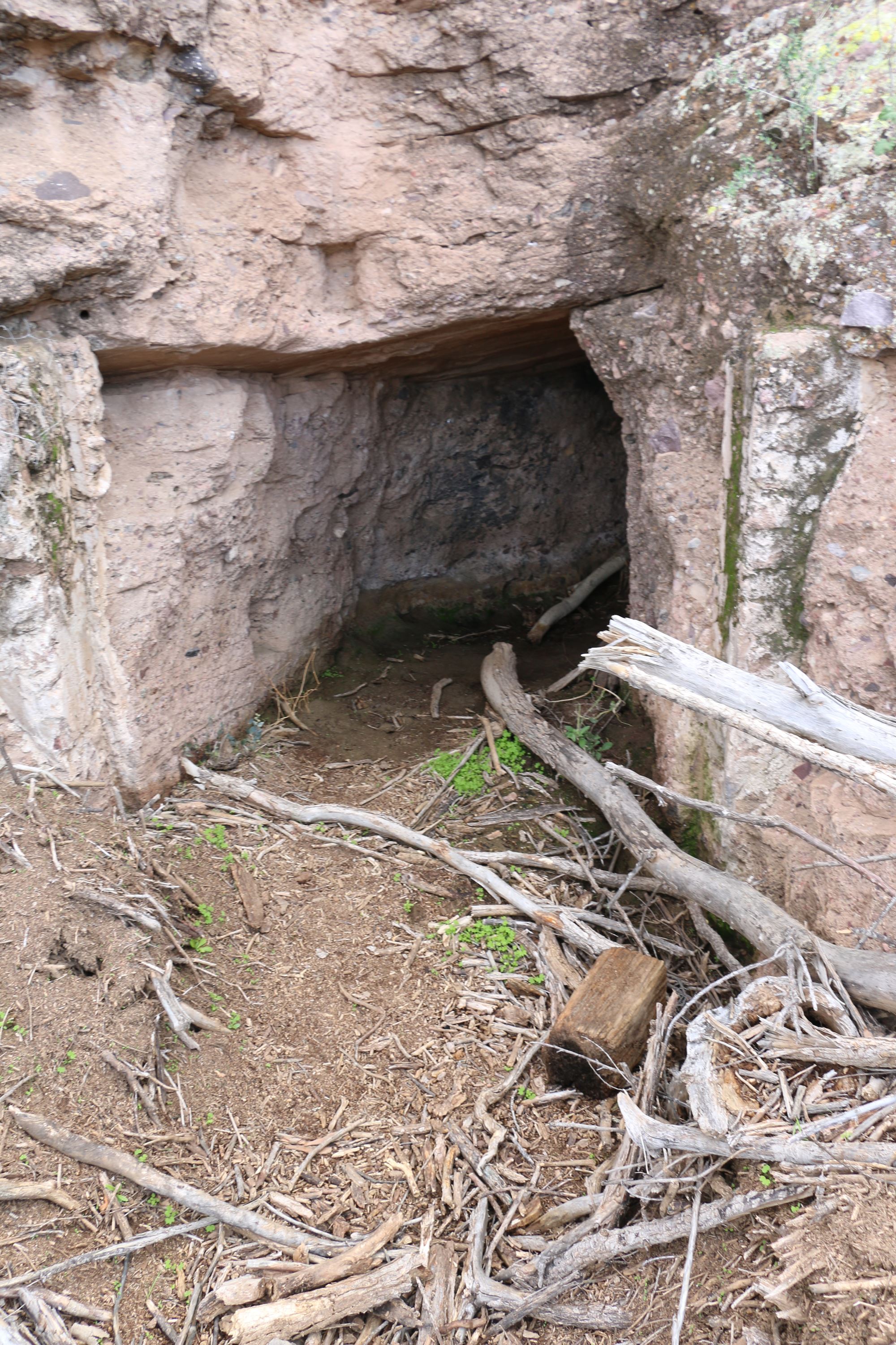
The cabin and numerous other structures probably date to as early as the 1930s. A dog grave, labeled “Pooch” near the cabin displays the dates 1928 to 1938. The main house consists of two primary rooms with several additions built on. On the north side of the house, crumbling walls have revealed a unique design technique used when building the cabin. To save on cement and construction costs, metal cans filled with dirt were stacked to make up the foundation of the wall. Cement was then poured on top of this. Except for one small collapsed section, much of the structure of the house remains in good shape. The roof has been destroyed by decades of wind and rain.
When the Lake Pleasant Development Committee began planning Lake Pleasant, it was found that Johnson’s homestead would be within the boundaries of the lake. Since he would be underwater soon, he was forced to move out in 1994 against his will. When the lake was flooded, the boundaries came up quite short of Johnson’s homestead. Much of the graffiti on the walls of his home dates to 1994 when the homestead was abandoned. It has sat for 20+ years on the banks of Tule Creek and combined with China Dam, makes for an interesting day out on the trails. For more information on the trail and how to get here, see our Tule Creek/China Dam Trail page which has GPS tracks, video, and photos of the drive out.


Sources:
Du Shane, Neal. "FORT TULE." Arizona Pioneer & Cemetery Research Project. N.p., 23 Oct. 2007. Web. 03 Feb. 2017. <http://www.apcrp.org/FORT_TULE/Ft_Tule_%20102307.htm>.
"Lake Pleasant Regional Park." Wikipedia. Wikimedia Foundation, n.d. Web. 03 Feb. 2017. <https://en.wikipedia.org/wiki/Lake_Pleasant_Regional_Park>.
Golden Anchor Mine: https://www.mindat.org/loc-134787.html
Great Cross Cut Prospect: https://www.mindat.org/loc-134366.html
Messick Claim: https://www.mindat.org/loc-145154.html
Mystery Property: https://www.mindat.org/loc-145336.html