Offroading to the bottom of the Grand Canyon - 2015
We head 450 miles from Phoenix to the Grand Canyon using as few paved roads as possible
Every year for the past couple of years, my cousin and I always try and do an epic trip somewhere around Arizona. Last year, it was taking a new Camaro on a Route 66 Road trip. This year, I had a different idea. Last August I bought my first Jeep and entered the world of customization and “Jeeping”. So, that gave me an idea which, after months of planning, was about to finally become a reality this past May 2015.
The route we would be following for this trip
The challenge: make it from my house in the suburbs of west Phoenix to the Colorado River at the bottom of the Grand Canyon using as few paved roads as possible. Of course, this meant planning an epic 4-day journey along some of the toughest and most scenic off-road trails in Arizona.
The route: Our planned course would take us 450 miles across Arizona, beginning at I-10 in Avondale, up the Hassyampa River, along the Backway to Crown King to Horsethief Lake. Then, it’d be up Senator Highway, over to Jerome via old railroad trails and into Sedona. From there, we would hit Broken Arrow, Schnebly Hill Road, Cinder Hills OHV Area, and a series of forest roads to head north and eventually west around the San Francisco Peaks and over to Peach Springs. Once in Peach Springs, we would follow Diamond Creek Road as it drops over 3,000 feet to end at the Colorado River in the Grand Canyon. Of course, all of this would require a capable vehicle. The Jeep Grand Cherokee is a dependable offroad vehicle that should be able to handle all aspects of the trip.
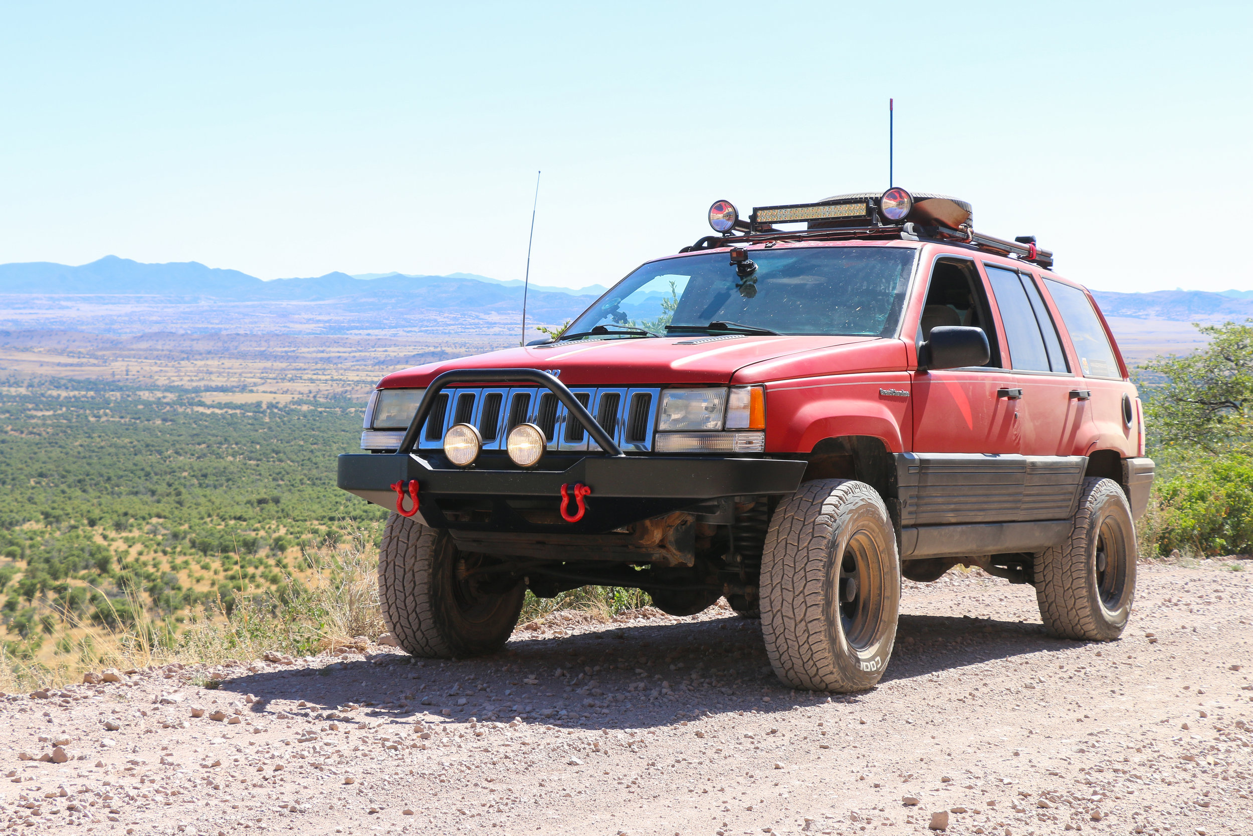
The vehicle: For this trip, I would be using my very own 1994 Jeep Grand Cherokee. With a big, 5.2L V-8 engine, we would have 220 horses and 280 ft-lb of torque at our disposal. The Jeep also has had a 3.5” suspension lift, 31” tires, skid plates, a custom roof rack, 2 spare tires, and plenty of lights in addition to some other upgrades. All of this would hopefully be enough for our 400+ mile offroad journey across Arizona
Day 1:
It was about 12:30 P.M. when we had finally packed the Jeep up and hit the road. For the first leg of the journey, we would have some family tag along in a second vehicle to provide moral support before splitting off on our own in a couple of hours. From Avondale, we hit Loop 303 northbound and set our sights for the Hassyampa River. The miles rolled by and about an hour later, we pulled of the US-60 in Morristown to play around in the Hassyampa for a little bit. Here we got a taste of our first offroad experience of the trip. In the river bottom, we navigated the open Hassayampa and headed to the scenic red cliffs before turning back. As we headed north, we left the Hassyampa and used dirt roads to connect with AZ-74. Along the 74, we headed east 25 miles to Castle Hot Springs Road.
In the Hassayampa River bottom
Stopping for a break at CK rock along the Backway to Crown King
Parked in downtown Crown King
It was about 3:00 P.M. when we wound past Lake Pleasant and hit our first air-down point at the start of the 26 mile long Backway to Crown King. As the road split from Castle Hot Springs Road, Daniel and I (Scotty) left behind our moral support and with low tire pressure, embarked on what would surely be an insane journey. The first 15 miles passed quickly as we settled in to the Jeep. Without any major obstacles, this portion of the trail made it easy to underestimate the trail as a whole, as we would soon find out. After taking a break at the famous “CK” rock, and posing the Jeep for pictures of this well-known landmark, we continued east as the trail quickly got narrower and steeper. From this point on things would get significantly rougher until we reached Crown King. Hills came and went and the Jeep was appearing to handle things quite nicely, that is until the check engine light came on a few miles later. After pulling off the trail to see what was going on, we decided to give the Jeep a break before continuing on. While we were lucky enough to have cooler-then-average May temperatures, we were now wheeling at the hottest part of the day (high-80’s today), a big no-no if you’re trying to go easy on your vehicle. After attributing the check engine light to a faulty fuel injector wire, we pressed on. The hills got slightly rougher and at this point, we were surprised by what we came across next. Out here, in the middle of freaking nowhere, sat a Dodge Neon. Much to my amusement (my cousin Daniel owns a Neon) we joked, and seriously wondered how that car made it this far into the mountains. Not wasting too much time, we continued on. It was getting late in the day and we had begun to hit traffic returning from Crown King.
The trail to Horsethief Lake
It was after 5:00 P.M. when we finally crossed into the Prescott National Forest. While the trail was more shaded, things got rougher still. The trail certainly wasn’t difficult but crossing through boulder-strewn creeks and climbing up rock ledges, things were pushing the edge of ‘moderate’. Then it happened. The Jeep decided it had enough of the bumps and bucked before stalling out and coming to a dead stop in the middle of a pretty tight section of trail. How could this happen so soon? While we were on the second toughest trail of the trip, this was an unsettling sign of finishing the trip. Things were doubtful. The Jeep wouldn’t restart so I popped the hood. After looking things over and willing the Jeep to start again it did. We were on our way, hoping that it wouldn’t happen again. After some narrow climbs, we passed through the rough section around Oro Belle. Here, there was water on the trail and navigating the rocky creek bottom proved to be quite bumpy.
Finally, around 6:00 P.M. we were on the final ascent into Crown King. One last huge hill and we had finished off the challenging Backway to Crown King. Fighting sun in our eyes, we made it up the hill and onto easier roads. By 6:45, we were rolling across the bridge into downtown Crown King where we decided to stop for dinner. But there was another problem. Nothing was open. Again, luck wasn’t on our side. Everything in Crown King closes at 6:00 on a Sunday since all of their customers have already left by this time. With no options for food, we figured to head for our cabin near Horsethief Lake, 6 miles from downtown. We continued back up the road and split off the road towards Horsethief. The miles seemed to crawl by. The trail was bumpy, we were hungry, it was getting dark soon, and after a brutal day, we were ready to stop for the night. A couple miles from the cabin we came across a view that stopped us in our tracks. The sun was setting and the entire southern half of the Bradshaws were in full view of the trail. We pulled off and enjoyed the moment, which almost made the whole days efforts worth it. As the sun set, darkness crept over the mountain peaks and the trail we had been on a few hours before was lost in the shadows. We pressed on, and by 7:45, had reached our stop for the night.
We quickly unlocked the gate to the cabin and pulled in to get unloaded. While quaint, the cabin had everything we needed, including a new addition: electricity. We got food going in the oven while we brought our belongings inside for the night. The day had taken a toll on everyone. Daniel was beat. I was dead-tired. The Jeep managed to make it but had a few difficulties of its own along the way. We called it a night around 10:30 because we knew that our journey was only just getting started.
Heck of a view along Horsthief Trail as the sun set on our first day
Horsethief Cabin at night
Day 2:
Refreshed and reenergized, we were up at the crack of dawn, then, hit snooze and slept in for 4 more hours. It was 10:00 A.M. when we had packed up our belongings, checked out the cabin, and headed down the road half a mile to have breakfast at Horsethief Lake. Just like the log book at the cabin said, we were joined for breakfast by our new best friends, a whole family of ducks. They enjoyed our donuts almost as much as we did. We checked out the surrounding area and were on the road, well – trail again by about 10:30. We took the 6 mile side-trail back to the “main road” where we continued left, onto Senator Highway. Senator Highway was built in 1866 and connected the well-to-do town of Prescott to the numerous mines to the south. Today, it would bring us 37 miles from the heart of the mountains near Crown King, into Prescott. The road quickly leaves Crown King and passes underneath the towering and aptly named, Towers Mountain. After twisting and turning on the single lane trail, we headed in a northwesterly direction. We crossed a few wet spots on the trail in addition to some trail maintenance before arriving at Palace Station, an old stage stop just before 1:00 P.M.
Horsethief Cabin in the morning
Horsthief Lake
Stopped at an old corral along Senator Highway
The trail up to this point hadn’t been too difficult – throwing a few rocky sections along creeks and some tight spots, it had been no problem for the Jeep. Things stayed rough after leaving Palace Station, but got progressively more graded and wider as we approached Senator Mine. By 1:30 P.M., we were stopped and exploring what’s left of Senator Mine, the namesake for the entire trail we had been on so far. A few old metal structures and lots of cement foundations adorned with graffiti remain. We continued on, finishing up the last few miles of Senator Highway at the quickest rate since 3:00 P.M. yesterday. Once on the strange-black surfaced trail again, we aired up. We had been off-road for the last 75 miles as we journeyed from Lake Pleasant, up through Crown King, and finally to near Prescott before back on pavement. We quickly passed through Prescott, replenishing some supplies and picking up ice for the coolers. We continued north and had lunch in Chino Valley. Here, we were able to catch our breath for a little while.
Senator Highway
Palace Station along Senator Highway
Senator Highway north of Palace Station
United Verde RR bed heading towards Jerome from Chino Valley
At around 4:00 P.M. we left Chino Valley and headed due east along Perkinsville Road. A few miles outside of town, we split off from the main road in favor of a lesser traveled but straight as an arrow former railroad bed that aimed us towards Jerome. Unfortunately, the bumpy trail kept us going slower than we liked and we couldn’t make up any time for our extended night’s sleep. We were buzzed by some helicopters doing training flights from Embry Riddle as we got closer to the mountains. The grassy plains and ranches gave way to high-desert vegetation and rocky terrain. After some questionable route-finding and consulting a few maps, we had found the right trail. At this point, the trail got extremely narrow as it hugged a cliff. We were still on the old United Verde Railroad bed and that was clearly evident at this point. The extremely rocky and lightly-traveled trail kept us at a crawl. Hopefully, we wouldn’t have to pass anyone.
Cattle tank along Jerome-Perkinsville Road
By 6:00 P.M., what felt like days later, we had climbed up to the significantly easier Jerome-Perkinsville Road. From here on out, it would be a cake walk. We let our nerves settle down from the past 20 miles and enjoyed the view of the Verde Valley. We continued east along the high-shelf road as it wound its way towards Jerome. The local welcoming party (a herd of cattle) made sure we were doing a safe speed on the road. Finally, by 6:30 we had reached a high-point and dropped down into the small mining town of Jerome. Clung to the side of a mountain, Jerome certainly is a unique place to visit, but again, we found the streets empty. We made up some time heading down the mountain as we passed through Clarkdale and Cottonwood. We were just outside of Sedona on 89A when the Jeep bucked again. Luckily, because we were at higher RPM’s it didn’t stall but it was a harrowing reminder of what could have happened deep in the mountains between Chino Valley and Jerome. We rolled into Crescent Moon Ranch, through a locked gate, to the site of our next cabin just before sunset. We were slightly amazed by what was waiting for us.
Crescent Moon Ranch is a huge, and perfectly set cabin that is available for rent at the base of Cathedral Rock and within a 5 minute walk of Oak Creek. We couldn’t believe that this place was ours for the night. It was a shame that we didn’t have more people that could enjoy it with the two of us. We watched the sun set again and Cathedral Rock jumped into the shadows of twilight as we unpacked the Jeep once again. Unlike Horsethief Cabin the night before, there was an abundance of space to throw our stuff. We prepped dinner, watched a movie, and enjoyed the night talking about our epic journey the past two days.
Taking a break in Jerome
Crescent Moon Ranch at night
Cathedral Rock as seen from Crescent Moon Ranch
Day 3:
The next morning waking up with Cathedral Rock out our windows was quite a treat. We got up and explored the area around the cabin. After loading up the Jeep, it was hard to say goodbye to this place. Finally, around 11:00 A.M., we were on the road towards Sedona. After filling up, we joined the numerous Jeeps driving around Sedona. Navigating to our next trail took a little while and after numerous roundabouts, we finally found our trail along Morgan Road. We aired down in the lot at the start to Broken Arrow and mentally prepared for what was to come. This was by far the hardest trail along our route and the hardest trail I’ve ever taken my Jeep on. After the tires were low enough, we set out on the trail. We immediately began climbing over some pretty serious obstacles. The first one was a test to make sure we could make the rest of the trail. The Jeep did fine even though I heard noises my Jeep has never made before: tire squealing on rocks.
After backing to let a couple Jeeps pass and following some Pink Jeep Tours past Submarine Rock, we made our way to Chicken Point without any issues. A few of the hills had some pretty serious rock ledges and we had a little articulation crossing over some trail erosion but the Jeep was doing it. Although crawling along in 4-low, we were doing it. Just after noon, we made it to Chicken Point, the halfway and southern most point along the trail most people stop for pictures, lunch, or simply to enjoy the scenery. You are able to park your vehicle right on top of a rock ledge that looks south into an amazing open area. Of course, you’re surrounded by beautiful red-rocks and the red Jeep fit in quite nicely. At this point it all made sense. We had made it to this point, although not at the end of the journey, it seemed like a sign that this trip was going right. After taking some pictures of the landscape and even more of my Jeep, we continued on. Broken Arrow was only halfway over and the most challenging bits still laid ahead.
At Chicken Point along Broken Arrow Trail
We left Chicken Point and continued to climb up around the famous natural roundabout up and over red slick rock. With the Jeep making some crazy clunking noises from flexing so much, we stuck to the main trail as we drove literally over all the red rocks. After navigating through some tight trees, we arrived at the single hardest point on the trail: Devil’s Staircase. We parked the Jeep and went to scope out the obstacle.
Devil’s Staircase is a steep series of rock ledges that you have to drop down in order to re-connect with the exit route back into Sedona. The trail is barely wide enough for a vehicle with big rocks on both sides. The steep drops mean that you need high-clearance and plenty of protection underneath your vehicle should you scrape. With my adrenaline pumping and the cameras set up to capture whatever was about to happen, we climbed back into the Jeep. We slowly drove to the top of the staircase. As we slowly descended, tires squealed like crazy; the Jeep was pitched the furthest down I’ve ever seen it, and Daniel was sitting in the passenger seat questioning my sanity. It was too late now. We hadn’t come up the entire trail to chicken out here. With extreme focus and nerves flaring, we crawled down Devil’s Staircase without a problem. No contact with the bottom of the Jeep at all, only extreme tire flex the whole way down. We had done it, and with excitement in the air, we made it the rest of the way back to pavement. While the trail was only 3 miles long, we had spent over an hour crawling along at 5 miles an hour and stopping for breaks
Daniel & Scotty at Chicken Point
Devil's Staircase along Broken Arrow
By 1:00 P.M., we had made our way through Sedona to Schenbly Hill Road, which would bring us from Sedona up to I-17 for our journey north. We expected Schenbly Hill Road to be an easy and fun trail that climbed up onto the Mogollon Rim to connect with I-17. We were wrong. Schenbly Hill provided to be a bit slower and a bit more of a challenge then initially thought. Rocky for its entire length, it’s hard to keep up any speed at all without your vehicle violently shaking. After passing numerous Jeep tours and a rattlesnake, we continued the rapid climb. By about 2:00 P.M., we had reached the top, where the view again made up for the brutal drive we endured. Schenbly Hill Vista overlooks all of Sedona. We continued on, now hungry and running behind. The last few miles to get to I-17 were mostly wide and flat forest roads with an occasional mud-puddle to splash through to make sure we were awake. We again made it to pavement where we aired up before jumping onto the I-17 for Flagstaff.
At the top of Schnebly Hill Road
The view from Schnebly Hill Vista
Airing up before getting on I-17
Volcanic ash in Cinder Hills OHV Area
In Flagstaff, we had a late lunch before continuing northeast along Highway 89 towards Cinder Hills. We turned off the road onto Forest Road 776. Along its length, we were treated to an unusual landscape: volcanic cinders everywhere. We were now driving through the San Francisco Volcanic Field with its numerous cinder cones and unique terrain. Like sand but with bigger pebbles, we had fun romping through this strange looking place. After finding a bypass to connect to our next trail along Sunset Crater Loop Road, we were on pavement for less than a mile before turning off onto O’Leary Peak Trail.
Forest Road 545 heading west towards Highway 89
It was around 5:00 P.M. when we started this trail heading north on the volcanic rock. The narrow trail was quite smooth and a nice change of pace from earlier in the day. We cruised along the scenic trail as it wound along the flanks of O’Leary Peak, one of the more prominent volcanoes behind Sunset Crater. We began to head west and we again found ourselves on Forest Roads (Forest Road 545). After about 9 miles, we reached Highway 89, which we quickly crossed over the pavement to connect to our final trail for the day. Using Forest Roads 417 and 514, we crossed through sparsely populated ranch land before ending up in the forests directly north of Mount Humphrey’s. Here, we were treated to excellent views of the still snow-capped peaks as we neared the cabin. Finally, 15 miles from Highway 89, we reached the turnoff for our cabin. 1 mile down a puddle filled road and we were home for the night.
We were lucky enough to arrive in the daylight, about 6:30 P.M., all though not much of it remained. We prepped the cabin, unloaded our things yet again and spent some time relaxing. Kendrick Cabin, our base for the night sits in a huge meadow and overlooks the San Francisco Peaks. We waited for the sun to set and prepped a campfire. Sitting outside, we were treated to spectacular views of the night sky as we feasted on some roasted kielbasa. After putting out the campfire, we retreated in for the night. The temperatures dropped into the high 30’s and I regretted not getting the woodstove going. While Daniel is from Ohio, he was lucky to have the thicker sleeping bag and I, the thin-blooded Arizonian, shivered throughout the night. Regardless, the day had been tiring, covering 93 miles with more than half of those being off-road, again. We slept.
Forest Road 514 near Kendrick Cabin
Kendrick Cabin at night
The Jeep at night
Day 4:
After a cold night we awoke just after 9:00 A.M. We grabbed a bite to eat and sat out on the porch of the cabin. The snowcapped San Francisco Peaks sat across a wide meadow to the south of us. A muddy Jeep sat just north of us. Around 11:00 we began loading up the Jeep and prepping the cabin for our departure. After consulting a local forest map, we double checked our route for the day and set off to complete the last leg of what had been a pretty epic trip. From the cabin, it was only a couple miles back to Highway 180, where we turned left to head south towards I-40. Just 7 miles later we broke off the highway. Rather than driving all the way to Flagstaff to catch I-40, we opted for the scenic shortcut through the Coconino National Forest. We took Forest Roads 245 to 171 as we blazed past Lava River Caves to the west of Flagstaff. While it was a tempting side trip, we were focused on the task at hand – making it to the Colorado before the end of the day.
Inside of Kendrick Cabin
By about 12:30 we had romped through the forest and finally made it 10 more miles to I-40. We followed the unpaved section of Route 66 as it climbed through the highest point along all of Route 66 before dumping us into the interstate in Parks. For the next 96 miles, we were stuck on pavement as the boring miles slowly ticked by. In Seligman, we turned off I-40 and followed the lesser traveled Route 66 the rest of the way to Peach Springs.
It was just after 2:00 P.M. when we rolled into Peach Springs. At the Hualapai Lodge, we picked up the permits we needed for the final 20 miles and gave the Jeep a quick breather while we gathered ourselves. It was now or never. 430 miles down, just 20 more to go. We set off from Route 66 and began following Diamond Creek Road. From here on out, it was a straight shot to the finish line. Just a few miles outside of Peach Springs, the trail turns to dirt and quickly begins its rapid descent. Over the next 20 miles, it would drop over 3,000 feet. The further we drove into the canyon, the better the scenery got. Towering cliffs jut out of either side of the trail and we were beginning to feel quite small in the Jeep. The extremely washboard-y road made it hard to go quick. While we were anxious to finish the journey, we were forced to slow down or risk breaking something on the Jeep and ending our trip early.
Snowcapped Humphrey's Peak as seen from Kendrick Cabin
Picking up permits from the Hualapai Tourism Office
The views along Diamond Creek Road continue to improve the further you drive
The miles rolled by and as we approached the final 3 miles, the trail entered Diamond Creek for the rest of its length. A little water on the trail wasn’t going to stop us. We splashed through water that would be in the Colorado River in just a few minutes, giving the Jeep a drastically needed although incomplete bath. Crossing Diamond Creek one last time, we rounded the bend and saw it; the Colorado River –flowing strong and directly in front of us. We backed the Jeep right up to the water’s edge and got out to check things out. After showing the ranger our permits, we took in the view for a while. After traveling 450 miles over some of the most insane trails in Arizona we had completed the challenge. The Backway to Crown King, Jerome-Perikinsville trail, Devil’s Staircase, Schnebly Hill, and even Diamond Creek Road didn’t seem so bad in hindsight now that we had made it here.
At the Colorado River at the bottom of the Grand Canyon
The view from the Colorado River at the bottom of the Grand Canyon
Conclusion/Day 5, Thursday, May 21st: After we had finished at the Colorado River, we travelled the 20 miles along Diamond Creek Road as it rapidly ascended back into Peach Springs. From there we drove 96 miles back to Parks and stayed one more night in northern Arizona before returning home the next day.
Months of planning the route, customizing the Jeep, working out details was all worth it. This epic 4-day offroad expedition is something I won’t ever forget. Traveling from cabin to cabin across some of the most remarkable scenery in Arizona, all while pushing my Jeep to the limit will be with me forever.
Certainly the most epic trip we’ve done… at least until the next year’s trip.
Additional Info/Thanks:
U.S. Forest Service “Rooms with a View” Program:
Horsethief Cabin: http://www.fs.usda.gov/detailfull/r3/recreation/?cid=stelprdb5208858
Crescent Moon Ranch: http://www.fs.usda.gov/recarea/coconino/recreation/recarea/?recid=72113&actid=101
Kendrick Cabin: http://www.fs.usda.gov/wps/portal/fsinternet/!ut/p/c5/04_SB8K8xLLM9MS...
Spring Valley Cabin: http://www.fs.usda.gov/recarea/kaibab/recreation/recarea/?recid=11662&actid=101
Hualapai Indian Tribe
Special thanks to the Park Ranger at the bottom who talked with us about the trail and the area and let us fly the drone around and get several video shots.
Individual trail video from our trip is available in a playlist on Youtube: https://www.youtube.com/playlist?list=PLV9AcZJWLPrD4d8CqIelcqEPiEQ_MgibD
A four-part documentary of our trip is also available on Youtube (see the top of this page).
Special thanks to all the family and friends that provided support along the way and allowed us to do this epic trip.